
What’s the ongoing story: US President Donald Trump, in his speech at the United Nations General Assembly on September 23, said that climate change was the greatest “con job” ever. “All of these predictions made by the United Nations and many others, often for bad reasons, were wrong. They were made by stupid people that have cost their countries fortunes and given those same countries no chance for success,” he said.
Key Takeaways:
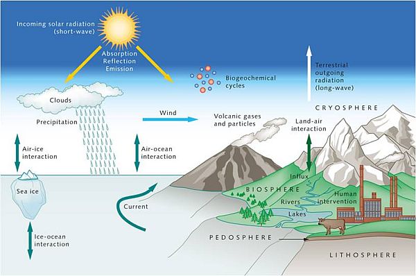
The predictions that Trump alluded to in his speech are usually made using climate models. These computer programs are at the heart of climate research: they help scientists understand how the climate changed in the past, how it is changing now, and how it might change in the future.
A climate model is a computer simulation that uses mathematical formulae and algorithms to replicate how the Earth’s climate system — including the atmosphere, ocean, land and ice — works.
Climate models can forecast how variables such as temperature and humidity will change over time under different scenarios, like increased greenhouse gas emissions or changes in land use. Simply put, they allow scientists to test hypotheses and draw conclusions on past and future climate systems.
Note that climate models are different from weather models. While weather models make predictions over specific areas and short time spans, climate models are broader and analyse long-term patterns.
Scientists then feed input data from observations, for example, of greenhouse gases or ocean conditions, and have the model solve equations to determine how the weather will change within each cell, what impacts those changes will have on adjacent cells, and what changes those adjacent cells will have on others.
The output from the model can include “projected changes in temperature and precipitation patterns, sea-level rise, ocean circulation, frequency and intensity of extreme weather events (such as heatwaves, droughts, and storms), and shifts in snow and ice cover,” Vidya said.
The earliest form of climate models, known as the Energy Balance Models (EBMs), emerged in the 1960s. Then came Radiative Convective Models (RCMs), which are more complex and simulate the transfer of energy through the height of the atmosphere.
Subsequently, General Circulation Models (GCMs), also called Global Climate Models, emerged. They are the most sophisticated and precise models for understanding climate systems and predicting climate change.
There are also Regional Climate Models (RCMs) that do a similar job as GCMs, but offer more precise local forecasts and concentrate on smaller regions, such as a country or a continent.
Researchers say that modern climate models are fairly accurate when it comes to capturing large-scale patterns and long-term changes, particularly at the global level.
That said, current climate models are not perfect. This is because of imperfect, incomplete, or unavailable data on complex, dynamic processes such as the nature of clouds, the climatic effects of sudden geophysical events such as a volcanic eruption, or natural phenomena such as El Niño events.
Climate models also overlook regional specifics such as intense rain in rural areas, flooding in urban areas, or heat in towns, as they view the Earth in broad sections, typically ranging from 100 to 250 kilometres (the size of each cell of the three-dimensional grid), according to Vidya.
The most glaring shortcoming of these models is that they tend to be less accurate in the Global South. This could be because of inadequate ground data, and more complex and poorly represented regional climate patterns, such as the Indian monsoon.
These flaws, however, do not mean that climate models are useless. Since they are based on well-founded physical principles of Earth system processes, climate models are still one of the best ways to understand general climate patterns and make policy decisions to mitigate the adverse effects of climate change.
As such, almost all climate models and climate scientists agree on one fundamental fact: that climate change is real , and the rise of the global mean surface temperatures is due to the continuing emission of heat-trapping greenhouse gases.
Note:
It was reported in May that the India Meteorological Department (IMD) will soon adopt the Bharat Forecast System (BFS) which offers the highest resolution among weather models. This move will significantly enhance the IMD’s weather forecasting capabilities, especially with respect to extreme rainfall and cyclones.
Developed by Pune -based Indian Institute of Tropical Meteorology (IITM), the BFS offers a spatial resolution of 6km x 6km, making it the first weather model with such high resolution. In fact, weather modellers have also been working to fine-tune this resolution to 3km and 1km.
Currently, the IMD operates Coupled Forecasting System (CFS) developed under the Monsoon Mission Project. The original model framework of CFS was developed by US-based National Center for Environmental Prediction.
For Indian use, it was modified to provide forecasts for the Indian monsoon region for different spatial and temporal resolutions. In addition, it also runs the Global Forecasting System (GFS), which a coupled model (factors-in ocean and atmospheric parameters), for issuing the weather forecasts at time scales ranging from a few hours, to five days, a month to a season.